|
|
Post by alicarr on Nov 22, 2018 10:29:55 GMT
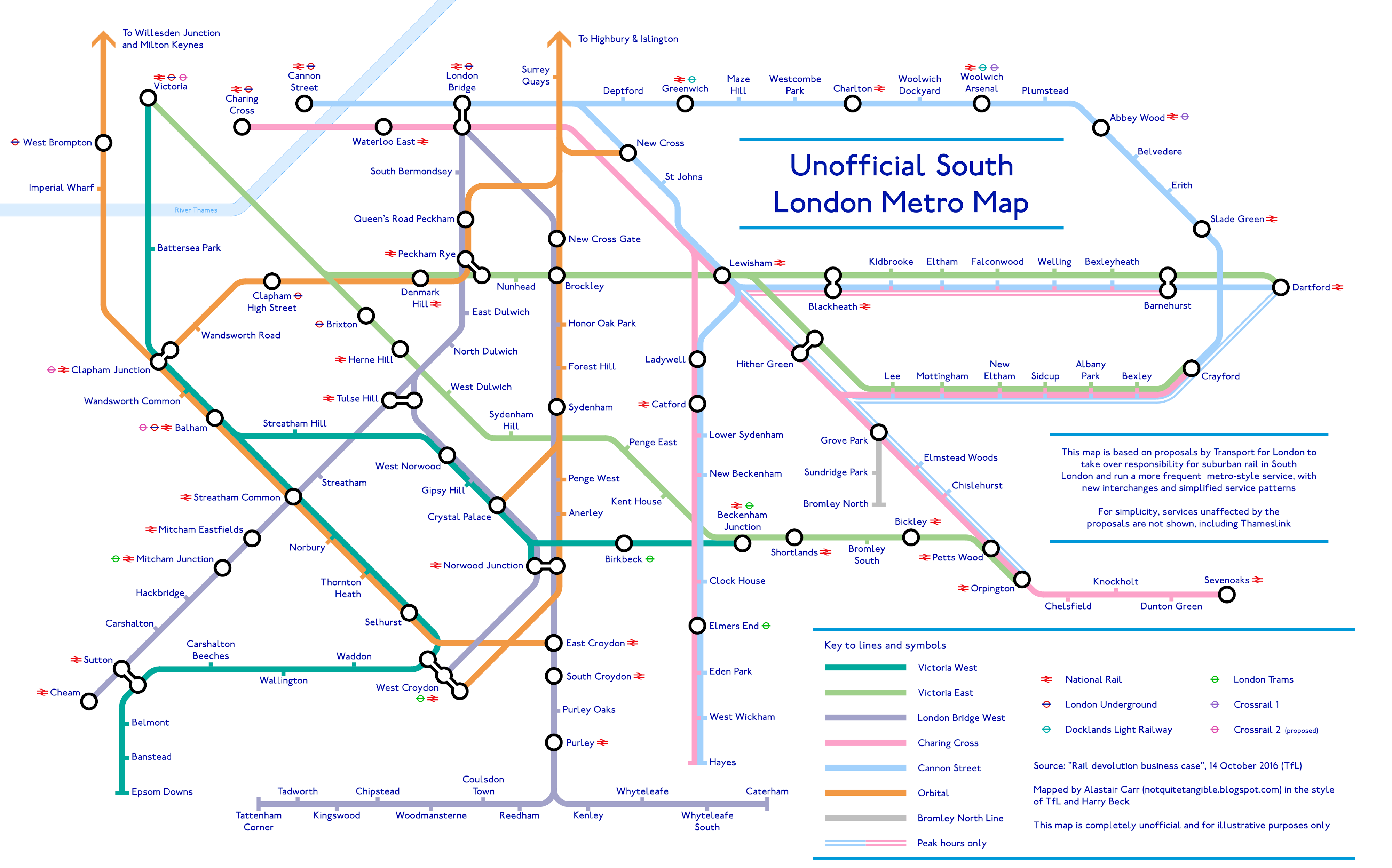
I've got another Tube map to share! This is based on the proposals from 2016 (which reappeared in the Mayor's Transport Strategy this year) to devolve control of suburban rail services in South London to TfL and create a "South London Metro":  Given the complexity of the rail network in South London, I was keen to try and keep the map as simple as possible. This is why there are different colours for the different London termini. This is also why many rail routes are not shown on the map: including Thameslink, and longer-distance services whose frequencies would be unaffected by the proposals. I've now got a blog ( notquitetangible.blogspot.com) where I'm posting the Tube maps, including a couple which I've shared on this forum before. I'm currently working on a Tube map which is a little more 'fantasy', reimagining the London Underground in the gridlike shape of the Beijing Subway. This is what the central section looks like so far. Let me know what you think! |
|
londoner
thinking on '73 stock
Posts: 480 
|
Post by londoner on Nov 22, 2018 10:39:33 GMT
The map emphasizes how ridiculously complex the south London rail services are and why a potential TFL takeover should first be thoroughly reviewed.
|
|
class411
Operations: Normal
Posts: 2,743 
|
Post by class411 on Nov 22, 2018 11:00:33 GMT
What would that mean in relation to, for example, a train running from Victoria to Dover?
Presumably they were not planning to separate 'metro' trains, so what would happen at the boundary?
Unless it's just a 'fares and finance' thing, this seems beyond half baked. And even 'fares and finance' would be horrendously complicated to plan, agree, and implement.
|
|
Chris M
Global Moderator
Forum Quizmaster
Always happy to receive quiz ideas and pictures by email or PM
Posts: 19,758
|
Post by Chris M on Nov 22, 2018 11:46:02 GMT
So no Woolwich to Lewisham service? That wont go down well as those were always well used trains when I lived in the area.
|
|
|
|
Post by norbitonflyer on Nov 22, 2018 11:57:05 GMT
What would that mean in relation to, for example, a train running from Victoria to Dover? . The same as currently happens to Liverpool Street to Stansted services, for example - or Marylebone to Aylesbury. They share tracks with the Metro services. (This is presumably why here is no off peak service shown to Dartford via Sidcup - these continue beyond Dartford, and would remain with SET. So no Woolwich to Lewisham service? That wont go down well as those were always well used trains when I lived in the area. Likewise, this service goes beyond Dartford. I would prefer non-TfL services to be shown in some way, perhaps as a narrower line, but that is not TfL's way. One oddity on the map is that the NR interchange symbol is shown at all stations Beckenham Junction to Orpington, except Bromley South! If this is to take account of the Thameslink services sharing that route, Bromley South (and also Penge East, Sydenham Hill and West Dulwich should have the symbol), but the usual convention is not to show interchange at intermediate stations on lines where two all-stations services operate (so Gunnersbury and Richmond, but not Kew Gardens), so here we would expect Herne Hill, Beckenham Junction, Shortlands, Bromley South and Orpington to have the symbol, but not the intermediate stations. The map emphasizes how ridiculously complex the south London rail services are and why a potential TFL takeover should first be thoroughly reviewed. Not as complicated as the Tube network, although I would suggest the map might be clearer if the "London Bridge" routes were split as the Victoria ones have, into a "via Forest Hill and a "via Tulse Hill" group, and that the West London Line/East Croydon route be shown separate from the other Overground lines. But if these lines were to be taken over and run as part of the Overground, we would just get a confusing tangle of spaghetti-in-tomato-sauce, because branding is so much more important than clarity. |
|
|
|
Post by alicarr on Nov 22, 2018 12:05:34 GMT
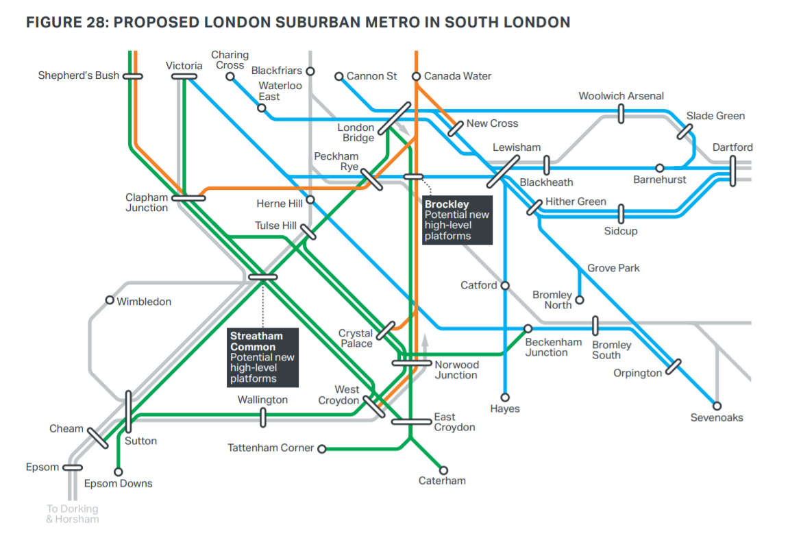
So no Woolwich to Lewisham service? That wont go down well as those were always well used trains when I lived in the area. My understanding is that this route would still run but wouldn't get devolved to TfL. (Which may be what you meant - not sure whether you meant "no Woolwich to Lewisham service devolved to TfL" or "no Woolwich to Lewisham service at all".) It's shown in grey ("May not be contracted to TfL for operational reasons") in the map below (from the Transport Strategy):  So for this reason I didn't mark the route on the map (but gave Charlton and Blackheath interchange symbols). I've found that making this map involves walking a thin line: show too many lines and you get a complexity overload (the complexity is already high, as londoner notes), show too few and you wonder what happens to all these services that wouldn't get devolved. |
|
|
|
Post by alicarr on Nov 22, 2018 12:32:24 GMT
One oddity on the map is that the NR interchange symbol is shown at all stations Beckenham Junction to Orpington, except Bromley South! If this is to take account of the Thameslink services sharing that route, Bromley South (and also Penge East, Sydenham Hill and West Dulwich should have the symbol), but the usual convention is not to show interchange at intermediate stations on lines where two all-stations services operate (so Gunnersbury and Richmond, but not Kew Gardens), so here we would expect Herne Hill, Beckenham Junction, Shortlands, Bromley South and Orpington to have the symbol, but not the intermediate stations. My understanding is that Petts Wood definitely needs at least an interchange circle (since you could use it to change between Chislehurst and Bickley, for example). Then my understanding is that you never leave off the NR symbol from any interchange-circle station served by NR, even if it's an intermediate station. This may not be correct, though - the science of interchange symbols is arcane! I think you're right about Bromley South and Bickley - I will correct these! |
|
|
|
Post by greggygreggygreg on Nov 23, 2018 22:37:34 GMT
What would that mean in relation to, for example, a train running from Victoria to Dover? . The same as currently happens to Liverpool Street to Stansted services, for example - or Marylebone to Aylesbury. They share tracks with the Metro services. (This is presumably why here is no off peak service shown to Dartford via Sidcup - these continue beyond Dartford, and would remain with SET. So no Woolwich to Lewisham service? That wont go down well as those were always well used trains when I lived in the area. Likewise, this service goes beyond Dartford. I would prefer non-TfL services to be shown in some way, perhaps as a narrower line, but that is not TfL's way. One oddity on the map is that the NR interchange symbol is shown at all stations Beckenham Junction to Orpington, except Bromley South! If this is to take account of the Thameslink services sharing that route, Bromley South (and also Penge East, Sydenham Hill and West Dulwich should have the symbol), but the usual convention is not to show interchange at intermediate stations on lines where two all-stations services operate (so Gunnersbury and Richmond, but not Kew Gardens), so here we would expect Herne Hill, Beckenham Junction, Shortlands, Bromley South and Orpington to have the symbol, but not the intermediate stations. The map emphasizes how ridiculously complex the south London rail services are and why a potential TFL takeover should first be thoroughly reviewed. Not as complicated as the Tube network, although I would suggest the map might be clearer if the "London Bridge" routes were split as the Victoria ones have, into a "via Forest Hill and a "via Tulse Hill" group, and that the West London Line/East Croydon route be shown separate from the other Overground lines. But if these lines were to be taken over and run as part of the Overground, we would just get a confusing tangle of spaghetti-in-tomato-sauce, because branding is so much more important than clarity. I would say it is more complicated than the Tube network, as the London Underground has all its lines physically and operationally separate, whereas the South London rail service is all connected and a delay on one part will spread to the rest |
|
|
|
Post by norbitonflyer on Nov 23, 2018 23:49:22 GMT
I would say it is more complicated than the Tube network, as the London Underground has all its lines physically and operationally separate Only really true for four, or possibly five, Underground lines. |
|

