Deleted
Deleted Member
Posts: 0
|
Post by Deleted on May 20, 2015 16:36:04 GMT
I read online somewhere that TfL has started the deployment of the May 2015 poster maps at some stations, just wondering if anyone has seen any up or any pocket maps at stations yet? FYI they have also added a section for TfL Rail below, online maps still to be updated www.tfl.gov.uk/modes/tfl-rail/ |
|
rincew1nd
Administrator
Junior Under-wizzard of quiz
Posts: 10,286 
|
Post by rincew1nd on May 20, 2015 17:14:10 GMT
Discussion about the website is here. Let's keep this thread about the map, shall we?
|
|
Chris M
Global Moderator
Forum Quizmaster
Always happy to receive quiz ideas and pictures by email or PM
Posts: 19,762
|
Post by Chris M on May 20, 2015 18:25:44 GMT
I've been looking for updated pocket maps, but haven't seen any yet.
|
|
|
|
Post by snoggle on May 20, 2015 19:13:58 GMT
The zoomable Tube Map on the TfL website has been updated to reflect the rail services that are added to TfL's portfolio from 31 May 2015. www.tfl.gov.uk/maps/track/tubeNo pdf version yet. |
|
|
|
Post by crusty54 on May 20, 2015 19:32:28 GMT
Really is the tail wagging the dog.
The pocket version will be unreadable.
|
|
Deleted
Deleted Member
Posts: 0
|
Post by Deleted on May 20, 2015 21:10:36 GMT
Looking at the map they have marked the wrong line at London Bridge as having no lift, on the map it says the Northern line has no lift but it's the jubilee line that hasn't got a lift at the moment.
|
|
|
|
Post by wimblephil on May 21, 2015 0:21:05 GMT
It does seem to have gotten to the point that the 'Overground' needs it's own map and line names/numbers!
Not that it'd help some people. Most people I know refer to all National Rail services as 'the Overground'...!
|
|
|
|
Post by snoggle on May 21, 2015 11:42:00 GMT
|
|
Deleted
Deleted Member
Posts: 0
|
Post by Deleted on May 21, 2015 12:12:28 GMT
How come when I go to the TfL website it isn't showing under the maps in the Tube section, is this posted on the internal site so far?
|
|
|
|
Post by snoggle on May 21, 2015 12:22:45 GMT
How come when I go to the TfL website it isn't showing under the maps in the Tube section, is this posted on the internal site so far? It's linked to from the Fares Release that I have mentioned in a new post in the Crossrail section of this forum. See the TfL Rail thread in that section. I dare say all the links will sort themselves out over the next few days as we approach the changeover date. There will be a load of documents and maps that need to be updated once the services transfer. |
|
Chris M
Global Moderator
Forum Quizmaster
Always happy to receive quiz ideas and pictures by email or PM
Posts: 19,762
|
Post by Chris M on May 21, 2015 14:11:49 GMT
Some changes between the PDF versions since December:
Addition of TfL Rail and new overground routes.
The Central line has gained a southwards kink between Bond Street and Queensway, just right to accommodate Crossrail, with consequent changes to the positioning of everything west of here.
The blobs at Stratford are now horizontally rather than vertically, with a kink in the Jubilee line and the DLR to Stratford International now running around two sides of a square rather than diagonally.
There is a new kink in DLR after King George V so the line into Woolwich arrives from the north not the north west
London Bridge returns to a single step-free blob for both lines.
...
|
|
Deleted
Deleted Member
Posts: 0
|
Post by Deleted on May 21, 2015 15:48:51 GMT
Interesting how they already mention the night tube on the right hand side
|
|
Deleted
Deleted Member
Posts: 0
|
Post by Deleted on May 21, 2015 16:21:55 GMT
Some changes between the PDF versions since December: Addition of TfL Rail and new overground routes. The Central line has gained a southwards kink between Bond Street and Queensway, just right to accommodate Crossrail, with consequent changes to the positioning of everything west of here. The blobs at Stratford are now horizontally rather than vertically, with a kink in the Jubilee line and the DLR to Stratford International now running around two sides of a square rather than diagonally. There is a new kink in DLR after King George V so the line into Woolwich arrives from the north not the north west London Bridge returns to a single step-free blob for both lines. ... I noticed Tufnell Park is closed as well. There may be other changes, I haven't looked properly yet. I must say, it's not too bad, but the orange and white monster is, as many have said (probably including me), getting way out of hand. It's already got more than three heads... Edit: Also, West Ham has lost its pyramid of blobs, they now run diagonally. Disabled access blobs obviously have returned to the LU lines and the dagger is gone. |
|
Chris M
Global Moderator
Forum Quizmaster
Always happy to receive quiz ideas and pictures by email or PM
Posts: 19,762
|
Post by Chris M on May 21, 2015 17:27:02 GMT
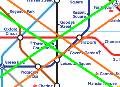
The proportions of the grided area have changed too, in December they were 1.52:1 they are now 1.42:1 - slightly squarer. I don't know why this is as it's east-west space that seems to be at a particular premium. Unsurprisingly the map has shifted too. In December the centre of the map was just southwest of Tottenham Court Road (on the "h" in t, now it is between Covent Garden and Holborn:  The background is the May map, the orange cross shows the centre of the May map. The green cross shows the centre of the December map when overlayed and positioned so the intersection of the Central and Northern lines is in the same place. The kink on the Central Line between Bank and Holborn has moved so that Chancery Lane is now on the diagonal line and St Paul's on the horizontal. At Bank the DLR blob is now northeast of the Northern line blob not due east. The zone 1 has been horizontally compressed slightly and the placement and spacing other things is sometimes very different - the northern ends of the existing lines are shorter by 0.9 to 1.5 station intervals. The text is slightly smaller, allowing things like Woodford, South Woodford and Snaresbrook to be labelled inside rather than outside the loop. The Piccadilly Line is now slightly further away from the District and District and Circle lines from South Kensington westwards. This means there is now space between the Picc and District stations at Gloucester Road, Earl's Court and Hammersmith. The latter has gained a link, the others have not. The Picc Heathrow branch now turns SW after rather than before South Ealing. The two Overground blobs at Clapham Junction are much further away, linked in the same manner as the Clapham North-High Street OSI rather than immediately adjacent. Overall, it looks like everything has been moved to fit the full Crossrail in, leading to lots of unnecessary corners in this version - it's messier than it has been of late. |
|
|
|
Post by snoggle on May 21, 2015 17:38:25 GMT
Overall, it looks like everything has been moved to fit the full Crossrail in, leading to lots of unnecessary corners in this version - it's messier than it has been of late. I certainly hadn't spotted all the changes you have but I had reached the same conclusion re Crossrail. It does look like the basic structural change to accommodate Crossrail has been made now thus making future changes easier. |
|
|
|
Post by rsdworker on May 22, 2015 17:41:44 GMT
Looking at the map they have marked the wrong line at London Bridge as having no lift, on the map it says the Northern line has no lift but it's the jubilee line that hasn't got a lift at the moment. PDF map shows the correct one - with No lift on jubbiee line |
|
Deleted
Deleted Member
Posts: 0
|
Post by Deleted on May 22, 2015 19:22:35 GMT
I saw that after I posted it.
|
|
gantshill
I had to change my profile pic!
Posts: 1,371
|
Post by gantshill on May 26, 2015 8:36:34 GMT
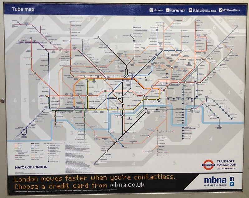
I saw a poster May 2015 map out of the train at Bayswater station this morning - travelling towards Edgware Road.
|
|
Deleted
Deleted Member
Posts: 0
|
Post by Deleted on May 26, 2015 9:15:18 GMT
Can you post a picture please?
|
|
gantshill
I had to change my profile pic!
Posts: 1,371
|
Post by gantshill on May 26, 2015 17:12:52 GMT
Sorry, I wasn't in a position to take a photo.
|
|
|
|
Post by Dstock7080 on May 28, 2015 13:16:35 GMT
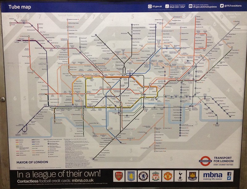
Can you post a picture please?  alternative adverts:  |
|
Deleted
Deleted Member
Posts: 0
|
Post by Deleted on May 28, 2015 19:11:11 GMT
I understand that there is very limited space on the map,
as well as that it is unadvisable to try spatially orient according to it, however does Leytonstone High Road really have to be placed on the opposite side from Central line as where it actually is ? It is fairly close, but still towards East, not West as on the map.
|
|
Deleted
Deleted Member
Posts: 0
|
Post by Deleted on May 28, 2015 19:15:17 GMT
I think so, what with Woodgrange Park there and there's the zone boundaries to consider as well. In order to have Leytonstone High Road on the "correct" side I suspect you'd have to make that map look very, very different indeed and remember the lines cannot be at arbitrary angles.
|
|
|
|
Post by crusty54 on May 28, 2015 20:19:45 GMT
It's no longer a Tube map.
So much work done in the 80s to get stations correctly aligned with each other and reduce the distance between Monument and Bank.
All gone.
Free magnifying glass with every pocket map?
|
|
|
|
Post by pridley on May 29, 2015 18:03:21 GMT
I wonder whether finally having Enfield, Edmonton, north Hackney and routes on TFL Rail on the map will have a profound change to these places? Certainly, Peckham has transformed since getting onto the Overground map as are, slowly, places on the way to Croydon.
I keep wondering whether this will be like a pressure valve release for Edmonton and Enfield in particular. For example, in Stoke Newington, 2 bed houses go for over £800k, whereas they are just above £250k in Edmonton. Just 10mins by train. And Hackney'ites who missed out on the North London Line revolution will be mindful of what Overground did for Hackney, whilst folk in Dalston with a £400k flat may look there for a three bed house if they have children on the way. Prior to the Silverlink takeover, it really had little of interest to the trendy crowd. Just three years ago, Homerton was a back water. They now appear to be taking over the mantle from Shoreditch and you can hardly find a spot now for a picnic on a cloudy Saturday afternoon at London Fields!
It almost feels like this is happening right about the right time and coinciding with a new office building boom around Liverpool Street that will no doubt bring a significant number of new commuters who will be looking for affordable places east of Stratford and north of Stoke Newington, or pricing out locals who will need to look further afield, as if they were not priced out enough already.
Not only that, but I think of how packed places like Hackney are and just imagine what it will be like further from London if the population does rise above 10 million, as predicted. We are talking about a 25% increase in London's population. The mind boggles.
For most people, and getting to know London is a complex job, nothing existed between the Piccadilly and Central Line.
|
|
|
|
Post by pridley on May 30, 2015 20:05:40 GMT
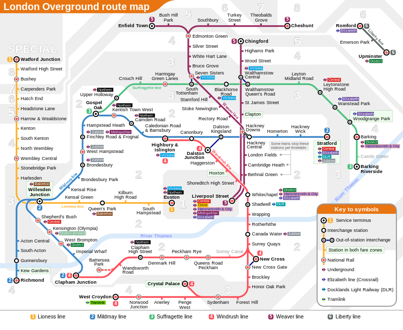
2015 Overground map. Looks a bit messy! Interestingly, includes Battersea Park despite that getting one or two services a day (maybe a change ahead there?) South Tottenham to Seven Sisters connection shown as is the Hackney Downs / Central (Why just rename Hackney Downs to have both being Hackney Central with the new link?). Romford to Upminster look silly. No doubt TFL will want to stop trains from not stopping at London Fields to Bethnal Green. I bet TFL also want Chingford trains to stop at all stations between Hackney Downs and Liverpool Street. It also feels silly seeing Cheshunt and Enfield Town going east and west of Edmonton Green, and Croydon being well east of Honor Oak, close to Clapham Junction! You can also see TFL gagging for an interchange between West Anglia and North London Line at Shoreditch High Street. Could that happen?  |
|
|
|
Post by wimblephil on May 31, 2015 0:45:29 GMT
Does look odd! It's like it's trying to be as geographical as it can, but as the same time not bothering at all!
|
|
|
|
Post by domh245 on May 31, 2015 1:06:12 GMT
That isn't a tfl official map, it doen't have the right text style marking the zones, nor the standard symbols.
Additionally, I don't see why Willesden - Clapham merits it's own route designator, especially when tfl lump it with the clapham - stratford services.
The routes I would have done are:
A: Watford - Euston
B: Richmond - Stratford
C: Clapham - Stratford
D: GOBLIN
E: ELL
F: Liverpool Street - Chingford
G: Liverpool Street - Enfield/Cheshunt
H: Romford - Upminster
The colours used on the designators should be different, and either all shades of one colour, or distinctly different shades - and they should match those used in the key
|
|
|
|
Post by Dstock7080 on May 31, 2015 2:41:25 GMT
|
|
|
|
Post by pridley on May 31, 2015 3:09:28 GMT
That isn't a tfl official map, it doen't have the right text style marking the zones, nor the standard symbols. I found it on Wikipedia. Thank you. Yes, somebody popped it up there before the real one was issued. Thank goodness its not a real TFL map!! |
|


