Deleted
Deleted Member
Posts: 0
|
Post by Deleted on Jan 31, 2010 13:31:08 GMT
I just bought the "London Railway atlas" (2nd Edition) from Joe Brown. It's very interesting, you can see the hole Track Layout of any railways in London... Thumbing through the Book i saw some sections with "right hand running" on London Underground... At White City it's because of the former Wood Lane Loop, between Borough and Bank it's explained here, between Warren Street and KingsX on the Victoria, it's because of better interchange at Euston, but Why is there right-hand-running at Kentish Town? |
|
|
|
Post by andypurk on Jan 31, 2010 14:08:30 GMT
but Why is there right-hand-running at Kentish Town? This isn't really right hand running. The northbound platform is above the southbound and the northbound line runs (more or less) above the southbound. |
|
mrfs42
71E25683904T 172E6538094T
Big Hair Day
Posts: 5,922
|
Post by mrfs42 on Jan 31, 2010 14:16:56 GMT
AIUI the line was built under the (now) A400 road which is the Kentish Town West road - changes to Fortress Road above roughly where the platforms end. This was because there was a stipulation at the time that these new railways could only be built under "public thoroughfares" as the legal papers term the roads. The railways could not deviate outside the boundaries of the road above, so where the road turns there is a need to squash the railways together. This results in a short bit of right-hand running at Kentish Town, because the road above turns both before and after the station. I've got a picture that will help to explain - I'll web it up in a mo. Version 1: 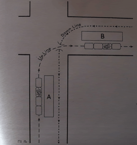 I'll tinker with Version 2: 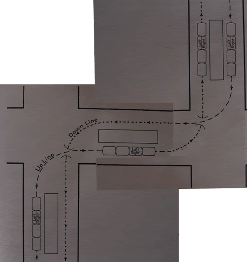 Does that make sense? It's only a quick 'n' nasty diagram, but it should suffice. |
|
|
|
Post by Tubeboy on Jan 31, 2010 14:21:28 GMT
And presumably the same reason for Tufnell Park?
|
|
Deleted
Deleted Member
Posts: 0
|
Post by Deleted on Jan 31, 2010 14:35:39 GMT
Ah k thank you :-)
|
|
Deleted
Deleted Member
Posts: 0
|
Post by Deleted on Jan 31, 2010 15:15:36 GMT
This was because there was a stipulation at the time that these new railways could only be built under "public thoroughfares" as the legal papers term the roads. The railways could not deviate outside the boundaries of the road above, so where the road turns there is a need to squash the railways together. AIUI, there was no general stipulation as to this: but where the railway could be built was laid down in its authorising act (including the limits of deviation), and it was 'better' (cheaper and easier to obtain authorisation) if the chosen route (as in the act) could be under highways (rather than adjacent buildings), so this was done wherever at all possible. Later it was felt that the advantages of a better alignment meant that the desire to build under highways could be relaxed. |
|
|
|
Post by abe on Feb 2, 2010 9:51:52 GMT
Back in the early days of tube railways a railway could only pass beneath property with the consent of the owner. Parliament agreed to grant free wayleaves (or easements) to railways beneath the streets, hence most lines followed the street layout.
Where a line wanted to pass beneath private property, there was no legal framework in place; if a wayleave could be negotiated then fine, but otherwise there was no option but to purchase the freehold - often at great expense. As can be imagined, the railways avoided this wherever possible. The thread about the C&SLR tunnels, linked in the first post in this thread, refers to Hibernia Wharf being tunnelled beneath. This would have been a privately arranged wayleave, and the railway would have paid the owners of the freehold for the privilege.
|
|
Deleted
Deleted Member
Posts: 0
|
Post by Deleted on Feb 2, 2010 16:54:47 GMT
Primrose Hill tunnels just outside of Euston on the WCML were built with a twist in the fast lines to avoid going under a property. The slow lines are straight!
|
|