|
|
Post by superteacher on Mar 18, 2018 10:35:37 GMT
Holland Park appears to be missing.
|
|
|
|
Post by alicarr on Mar 18, 2018 11:04:50 GMT
Holland Park appears to be missing. Someone on Reddit spotted this as well. Whoops! I'll correct the version on here - hopefully not too many people notice on the Evening Standard version.  |
|
|
|
Post by superteacher on Mar 18, 2018 14:20:16 GMT
Could the Crossrail 2 route between Victoria and Tottenham Court Road be straightened to avoid the double bend?
|
|
|
|
Post by alicarr on Mar 18, 2018 18:33:26 GMT
Could the Crossrail 2 route between Victoria and Tottenham Court Road be straightened to avoid the double bend? The double bend definitely is ugly. I remember trying lots of configurations, but I think this was the only one where I could fit all the text labels in. When I did the original Crossrail 2 tube map I had a small enough font that I could squeeze Crossrail 2 between Oxford Circus and Leicester Square - but I think this time the gap is just too narrow. But if you do have a specific idea that might work, I'd definitely be happy to give it a go! |
|
|
|
Post by superteacher on Mar 18, 2018 19:18:48 GMT
How about turning CR2 to 045 degrees just north of Vic and run it right the way through TCR? You could make room by moving the Central / Elizabeth line interchange circle to west of the station rather than east.
|
|
|
|
Post by alicarr on Mar 18, 2018 21:01:05 GMT
How about turning CR2 to 045 degrees just north of Vic and run it right the way through TCR? You could make room by moving the Central / Elizabeth line interchange circle to west of the station rather than east. I gave it a go: 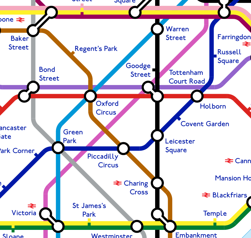 The issue I have is where to squeeze in the Tottenham Court Road label without it crossing over any lines. There could definitely be a way, though. |
|
Chris M
Global Moderator
Forum Quizmaster
Always happy to receive quiz ideas and pictures by email or PM
Posts: 19,397
|
Post by Chris M on Mar 18, 2018 21:57:00 GMT
Yea, as current positioned, the TCR label looks more associated with Holborn than the actual TCR.
If you moved the Warren Street label west of that station, and moved Goodge Street north with its label east of the station, would that give you room?
Maybe you get a little more space by moving Oxford Circus station slightly west, adjusting the position of the Vic and Bakerloo lines accordingly.
|
|
|
|
Post by whistlekiller2000 on Mar 18, 2018 22:08:15 GMT
Yea, as current positioned, the TCR label looks more associated with Holborn than the actual TCR. If you moved the Warren Street label west of that station, and moved Goodge Street north with its label east of the station, would that give you room? Maybe you get a little more space by moving Oxford Circus station slightly west, adjusting the position of the Vic and Bakerloo lines accordingly. Don't ask me why as I don't normally do things like this but I've just tried almost exactly what you've suggested there Chris and nearly ended up putting my head through the monitor. It's all so cramped around that area you could really do with Tottenham Court Road being renamed something really short........ |
|
|
|
Post by norbitonflyer on Mar 18, 2018 22:17:02 GMT
you could really do with Tottenham Court Road being renamed something really short........ If, as reported elsewhere, renaming a whole line only costs £5000, it might be the easiest solution. Tottenham Court Road is ambiguous as a name anyway - Goodge Street and Warren St stations are also on that thoroughfare, and between them are closer to 75% of it. How about St Giles or Centre Point? As the future interchange between Crossrails 1 and 2 what could be more appropriate? |
|
|
|
Post by superteacher on Mar 18, 2018 23:06:37 GMT
you could really do with Tottenham Court Road being renamed something really short........ If, as reported elsewhere, renaming a whole line only costs £5000, it might be the easiest solution. Tottenham Court Road is ambiguous as a name anyway - Goodge Street and Warren St stations are also on that thoroughfare, and between them are closer to 75% of it. How about St Giles or Centre Point? As the future interchange between Crossrails 1 and 2 what could be more appropriate? I’ve always liked the idea of the Centrepoint name. However, the Tottenham Court Road station name is so linked with that location now, I can’t see it ever changing. And if you start changing one ambiguous name, where do you stop? Would Embankment, Baker Street, Finchley Road, Old Street, Edgware Road etc need to change too? How about turning CR2 to 045 degrees just north of Vic and run it right the way through TCR? You could make room by moving the Central / Elizabeth line interchange circle to west of the station rather than east. I gave it a go: The issue I have is where to squeeze in the Tottenham Court Road label without it crossing over any lines. There could definitely be a way, though. How about: Move the Warren Street name so that it is west of the Northern line. Move the Goodge Street station tick a bit north, and insert the name to the east of the line. Squeeze in the Tottenham Court Road name into the space formerly occupied by the Goodge Street name. EDIT: Just realised that I’ve pretty much said the same thing as Chris M! |
|
|
|
Post by banana99 on Mar 19, 2018 0:26:44 GMT
Re Crossrail2. I didn't read it was calling at Warren St, and also it is a double ended connection to Euston and KX (rather than 2 separate stops as the map indicates). I think it may help you losing the Warren St constraint. Like others have said, it may help moving Oxford Circus west a little bit
|
|
|
|
Post by norbitonflyer on Mar 19, 2018 7:44:49 GMT
Re Crossrail2. I didn't read it was calling at Warren St, and also it is a double ended connection to Euston and KX (rather than 2 separate stops as the map indicates). Are you looking at the same map as me? Or have you confused the Victoria Line with CR2? |
|
|
|
Post by alicarr on Mar 19, 2018 8:11:16 GMT
Yea, as current positioned, the TCR label looks more associated with Holborn than the actual TCR. If you moved the Warren Street label west of that station, and moved Goodge Street north with its label east of the station, would that give you room? Maybe you get a little more space by moving Oxford Circus station slightly west, adjusting the position of the Vic and Bakerloo lines accordingly. Here are my attempts - one where I don't shift the Victoria and Bakerloo lines, and one where I do: 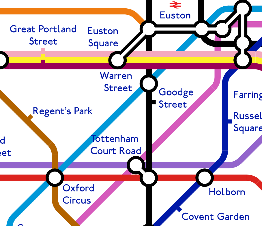 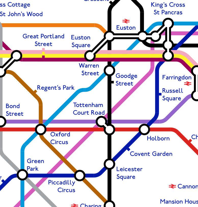 One of the tricky consequences of moving the Warren Street label left of the station is having it be a little too close to Euston Square - perhaps Euston Square could be moved back directly below Euston, but it would be hard to fit a label there. One of the nice aspects of the original map was that the Victoria line was a clean diagonal all the way through Oxford Circus, Warren Street and Euston - this isn't easy to have when Oxford Circus is moved to the left, since Warren Street can't go any further north without colliding with the Circle line. |
|
|
|
Post by whistlekiller2000 on Mar 19, 2018 8:47:46 GMT
Yea, as current positioned, the TCR label looks more associated with Holborn than the actual TCR. If you moved the Warren Street label west of that station, and moved Goodge Street north with its label east of the station, would that give you room? Maybe you get a little more space by moving Oxford Circus station slightly west, adjusting the position of the Vic and Bakerloo lines accordingly. Here are my attempts - one where I don't shift the Victoria and Bakerloo lines, and one where I do: One of the tricky consequences of moving the Warren Street label left of the station is having it be a little too close to Euston Square - perhaps Euston Square could be moved back directly below Euston, but it would be hard to fit a label there. One of the nice aspects of the original map was that the Victoria line was a clean diagonal all the way through Oxford Circus, Warren Street and Euston - this isn't easy to have when Oxford Circus is moved to the left, since Warren Street can't go any further north without colliding with the Circle line. Try making 'Warren Street' a single line of text, although you're still stuck with the 'Tottenham Court Road' problem which is the point at which I lost my temper with it. I'm not keen on the kinked Victoria Line arrangement though. |
|
|
|
Post by alicarr on Mar 19, 2018 9:33:24 GMT
Here are my attempts - one where I don't shift the Victoria and Bakerloo lines, and one where I do: ... One of the tricky consequences of moving the Warren Street label left of the station is having it be a little too close to Euston Square - perhaps Euston Square could be moved back directly below Euston, but it would be hard to fit a label there. One of the nice aspects of the original map was that the Victoria line was a clean diagonal all the way through Oxford Circus, Warren Street and Euston - this isn't easy to have when Oxford Circus is moved to the left, since Warren Street can't go any further north without colliding with the Circle line. Try making 'Warren Street' a single line of text, although you're still stuck with the 'Tottenham Court Road' problem which is the point at which I lost my temper with it. I'm not keen on the kinked Victoria Line arrangement though. Good point! A single-line Warren Street looks a lot better. I agree with you, having a kink in the Victoria Line isn't all that nice. 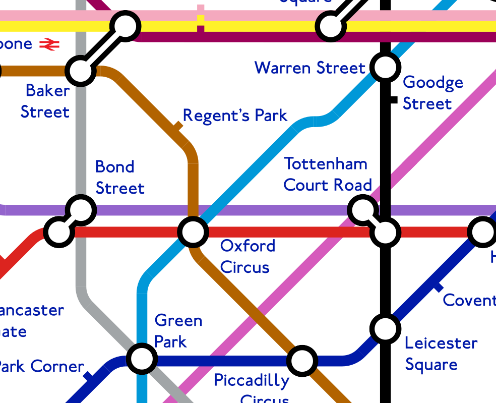 |
|
|
|
Post by superteacher on Mar 19, 2018 9:45:38 GMT
Let’s start a campaign to officially call Tottenham Court Road TCR! That would solve the problem because it would take up less space and thus enabling the kink in the Victoria line to be removed, if only to ease whistlekiller2000’s OCD! |
|
|
|
Post by alicarr on Mar 19, 2018 15:16:23 GMT
How does this look, in terms of Thamesmead extensions? I've dared go no further than Thamesmead since the Transport Strategy doesn't mention anything further (so no Abbey Wood or Woolwich). The District Line now has a 90 degree bend, but at least it's slightly more geographically accurate as far as Barking. 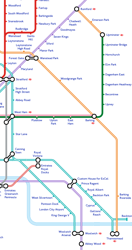 |
|
Chris M
Global Moderator
Forum Quizmaster
Always happy to receive quiz ideas and pictures by email or PM
Posts: 19,397
|
Post by Chris M on Mar 19, 2018 19:54:23 GMT
I think I'd prefer (or at least I'd like to see how it looks) with the district making the turn in two stages (i.e. with a diagonal stretch). Perhaps between Upton Park and East Ham to somewhere around the Dagenhams. Although this would move Barking and Barking Riverside further apart, this could be slightly mitigated by having the river run diagonally upwards east of Woolwich (which it does in reality).
|
|
Deleted
Deleted Member
Posts: 0
|
Post by Deleted on Mar 19, 2018 20:01:21 GMT
I like the way the DLR splits however, should Thamesmead recieve a NR logo? Won't it only have overground and DLR.
|
|
|
|
Post by alicarr on Mar 19, 2018 20:41:20 GMT
I think I'd prefer (or at least I'd like to see how it looks) with the district making the turn in two stages (i.e. with a diagonal stretch). Perhaps between Upton Park and East Ham to somewhere around the Dagenhams. Although this would move Barking and Barking Riverside further apart, this could be slightly mitigated by having the river run diagonally upwards east of Woolwich (which it does in reality). I'll see if I can get this cooked up for you. I've generally been following the philosophy that the fewer bends, the better: this is part of the reason why I removed the kink in the Northern line between Warren Street and Euston, and also why I removed the bends in the North London line and Goblin. I think one of Max Roberts's lectures on transit map design cites a study saying that one of the biggest factors which makes it harder to comprehend transit maps quickly is the number of bends - but perhaps a single 90 degree bend is no better than two 45 degree bends! Another proposal might be to bend the Elizabeth line directly east after (say) Forest Gate: this might mean that the District line wouldn't ever have to go vertical, and again would probably be more accurate than the Elizabeth line going at 45 degrees. But then horizontal lines always have the problem that it's harder to squeeze labels in. Edit: This is what I end up with: 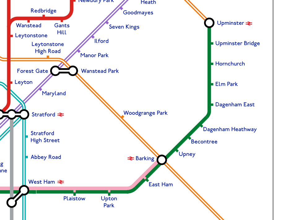 I will have a go at bending the Thames as well.  I like the way the DLR splits however, should Thamesmead recieve a NR logo? Won't it only have overground and DLR. Good spot!  |
|
|
|
Post by banana99 on Mar 20, 2018 1:06:11 GMT
Re Crossrail2. I didn't read it was calling at Warren St, and also it is a double ended connection to Euston and KX (rather than 2 separate stops as the map indicates). Are you looking at the same map as me? Or have you confused the Victoria Line with CR2? Er...probably Too many lines! |
|
Antje
侵略! S系, でゲソ! The Tube comes from the bottom of London!
Posts: 605
|
Post by Antje on Mar 21, 2018 23:38:06 GMT
The western Northern line will likely have its own name: the most rational option in my opinion is the lilac-coloured Hampstead line, after the Hampstead Tube. The eastern one would likely keep the old name for ease of recognition.
|
|
|
|
Post by superteacher on Mar 22, 2018 9:47:42 GMT
The western Northern line will likely have its own name: the most rational option in my opinion is the lilac-coloured Hampstead line, after the Hampstead Tube. The eastern one would likely keep the old name for ease of recognition. Batterware Line? I’m sure whistlekiller2000 would approve of that! |
|
|
|
Post by norbitonflyer on Mar 22, 2018 10:23:23 GMT
The western Northern line will likely have its own name: the most rational option in my opinion is the lilac-coloured Hampstead line, after the Hampstead Tube. The eastern one would likely keep the old name for ease of recognition. Maybe the Power Line, in view of its new southern terminus? However, I thought all new line names now have to have royal associations (Victoria, Jubilee, Elizabeth.....) It was a missed opportunity when the H&C was not called the Regency Line, passing as it does Nash Crescent, Regents Park, etc. Given its close association with the Victoria Line, maybe the Albert Line? Or, name it after Princess Charlotte, as the first female in the line of succession - the Lottie Line would go quite well with the Lizzie Line! |
|
|
|
Post by whistlekiller2000 on Mar 22, 2018 16:13:51 GMT
The western Northern line will likely have its own name: the most rational option in my opinion is the lilac-coloured Hampstead line, after the Hampstead Tube. The eastern one would likely keep the old name for ease of recognition. Batterware Line? I’m sure whistlekiller2000 would approve of that! An extremely unlikely scenario...... |
|
|
|
Post by holborncentral on Mar 23, 2018 0:58:03 GMT
The western Northern line will likely have its own name: the most rational option in my opinion is the lilac-coloured Hampstead line, after the Hampstead Tube. The eastern one would likely keep the old name for ease of recognition. I don't think that will happen. It would cost a fortune to change the name of that section of the Northern line. It's not as simple in real life as just changing the colour and name on the map. I think the Northern line should be kept as one or like what the OP has done, split it in two but keep the name. Thats the best way to manage it IMO. I actually have been running a Twitter campaign to keep the Northern line as one, but I havent updated the account lately. It's @foreveroneline for anyone on Twitter. It's separate from my main account |
|
|
|
Post by norbitonflyer on Mar 23, 2018 7:53:48 GMT
It would cost a fortune to change the name of that section of the Northern line. It's not as simple in real life as just changing the colour and name on the map. If it is split, I think the money will have to be spent - it would make no sense to have two separate lines with the same name and colour. Renaming stretches of line is nothing new - see the Hammersnmith & City (split from the Met, although it's not a complete split as they share tracks for some distance), or the renaming of the Hammersmith branch as joint H&C/Circle. In 1979 the Bakerloo was split when a short new branch was added - a close analogy with what is about to happen at Kennington. |
|
|
|
Post by simran1966 on Mar 30, 2018 16:32:20 GMT
Hello,
I was just admiring your map and noticed that Clapton and St James Street are switched (apologies if that was already pointed out).
It's great work - you've inspired me to start looking at Inkscape again.
Cheers,
Simon.
|
|
|
|
Post by alicarr on Mar 31, 2018 8:17:14 GMT
Hello, I was just admiring your map and noticed that Clapton and St James Street are switched (apologies if that was already pointed out). It's great work - you've inspired me to start looking at Inkscape again. Cheers, Simon. Thanks for spotting this - and I'm glad you liked the map! |
|
|
|
Post by stuartroy on Apr 4, 2018 11:03:26 GMT
With interchanges like Euston Square SSR - Euston Tube - CR2 - Kings Cross Tube - Kings Cross SSR, pretty soon we'll be able to walk around the entire system without needing to get on a train at all! Great diagram though, well done!
|
|