|
|
Post by Dstock7080 on Jan 6, 2018 14:15:09 GMT
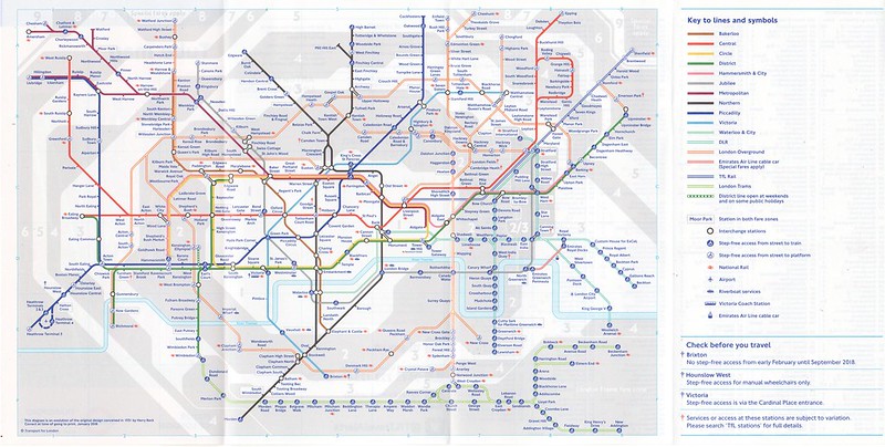
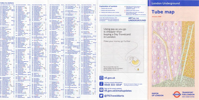
differences May 2017 to January 2018 pocket maps: - Archway to Upper Holloway link added - Barking (LO); now only step-free to platform - Bond Street; (Jubilee) step-free to train, (Central) step-free to platform added - Brixton; dagger added - Custom House for ExCel; reopened, dagger removed - Canning Town; dagger added - Gospel Oak; elongated link between LO stations - Holborn; dagger added - King’s Cross St Pancras (MET H&C); step-free to train restored - Lancaster Gate; dagger removed - Victoria (Victoria Line); step-free added; dagger added   |
|
rincew1nd
Administrator
Junior Under-wizzard of quiz
Posts: 10,286 
|
Post by rincew1nd on Jan 7, 2018 15:22:30 GMT
Edit: I just checked the page on the TfL website for Custom House, and it appears that they've moved the reopening date from late December to mid-January. Custom House reopens Monday 8 January. |
|
Chris M
Global Moderator
Forum Quizmaster
Always happy to receive quiz ideas and pictures by email or PM
Posts: 19,762
|
Post by Chris M on Feb 2, 2018 0:30:24 GMT
I've just seen that the digital map on the website is now dated December 2017. Below is a detailed list of every change from the July 2017 version I spotted:
Grid lines slightly thinner, station names very slightly bolder
Dark grey zones slightly darker (now #E6E7E8, previously #EDEDED)
Substantive changes:
Bond Street - now step free to platform (Central line) and to train (Jubilee line) meaning that it has gone from a single blob to a double blob. Marble Arch and Lancaster gate move slightly west in consequence.
Upper Holloway and Archway are now shown as an OSI. In consequence Archway is now slightly furhter north and Upper Holloway very significantly further west, Gospel Oak's Goblin blob moves significantly north east
Step-free access to King's Cross SSL restored.
Barking was previously a single step-free-to-train blob, but the Overground is now only step free to platform and so the station gains a second blob northwest of the District Line. In consequence Woodgrange Park moves north, causing Manor Park, Ilford, Seven Kins and Goodmayes to move northeast. The "s" of the Goodmayes label is now on the zone 4/5 boundary line (I'd mark this as a mistake if I were proofreading). The zone 3/4 boundary in this area is now much simpler, being straight north from East Ham to a right angle turn at Manor Park then west to beneath the "t" of Leytonstone.
Custom House reopens.
Daggers:
Losing daggers: Lancaster Gate (blue), Custom House (blue)
Gaining daggers: Brixton (blue), Canning Town (red)
Other changes: The blue dagger at Victoria is now vertically centred relative to the adjacent bus symbol rather than aligned the bottoms being level as before, the link to the NLL blob (which has moved north slightly, also moving Hampstead Heath, Highgate and East Finchley in that direction) is now only very slightly shorter than the Archway-Upper Holloway link.
Holborn gains a red dagger, causing consequential changes: The Central line dip (and Chancery Lane along with it) moves east to avoid the dagger, St Pauls stays in the same place relative to Bank and Cannon Street and so moves closer to the western end of the dip. The Eastern end of the dip also moves east by the same amount as the west, this in turn means that Liverpool Street moves east.
Other station label changes:
Victoria line blobs are now slightly further apart, meaning the Victoria line blob is slightly further north and the SSR blob slightly further west. Sloane Square has consequently moved west by the same amount.
St James Street, St John's Wood, St James's Park and St Pauls all lose the full stop after "St"
Kentish Town West and Camden Road both move closer to the Northern Line.
West Hampstead moves away from the blob slightly, Lloyd Park tran stop moves slightly closer
Finsbury Park moves southwest, Finchley Road and Frognal moves west slightly.
Stepney Green moves very slightly southwest, either causal to or consequential to TfL Rail line moving slightly south making the connector blob at Liverpool Street shorter.
Zone labels:
Right side of map between District and DLR - zones 3 and 4 labels now in line with horizontal gridline and no labels for zones 5 and 6. Previously labels for zones 3-6 were in line with the District - this arrangement was previously used in March 2017 (but not the maps before and after that one).
Zone 4 label south of Morden - moved slight right (closer to Merton Park tram stop) - probably due to key change (see below)
Zone 4 label east of Norwood Junction moved very slightly northwest, Zones 5 and 6 labels west of Ealing Broadway and zone 8 label by Cheshunt moved very slightly east, Zone 9 label in north east corner and "London Trams Fare Zone" label in south east corner moved slightly west - no obvious reason for any of these changes.
Zone 2 label west of Camden Town moved slightly west to be fully clear of Camden Town's dagger. The Zone 3 and 4 labels have both moved west by the same amount, presumably to stay in line, but also north by about the same amount for no clear reason.
Key: the lines above and below the key are slightly longer than previously, to maintain centreing this means the key has moved slightly right. The Zone 4-5 boundary now bends around the key from slightly further north in consequence.
|
|
|
|
Post by gals on Feb 2, 2018 23:44:53 GMT
Whole "2-3 zone" around Stratford has already bothered me by how odds its looked since the change last year (?) 2 years ago (?)
I dont understand why they dont just deal with it in the same way they do with the other boundary stations, all the stations even already have the contrasting box around the station name
|
|
|
|
Post by Dstock7080 on Mar 5, 2018 7:18:20 GMT
two new lifts, one to each platform were commissioned over the weekend at Bromley-by-Bow.
Will be interesting to see how quickly the information is updated.
|
|
Chris M
Global Moderator
Forum Quizmaster
Always happy to receive quiz ideas and pictures by email or PM
Posts: 19,762
|
Post by Chris M on Mar 5, 2018 12:51:35 GMT
I'd be amazed if there was a new paper map before May. A new digital map before then is more likely but I wouldn't put money on it.
|
|
Deleted
Deleted Member
Posts: 0
|
Post by Deleted on Mar 8, 2018 11:23:46 GMT
|
|
Chris M
Global Moderator
Forum Quizmaster
Always happy to receive quiz ideas and pictures by email or PM
Posts: 19,762
|
Post by Chris M on Mar 8, 2018 22:33:40 GMT
The only change is at Blackhorse Road, which is now 2 blobs rather than 1, with the Goblin becoming step free to the Platform. As a result, there has been a slight realignement of the line between Sotuh Tottenham and Walthamstow Queen's Road (the diagonal line has moved slightly east) and the Victoria line station blob has moved significantly closer to Tottenham Hale. edit: I haven't been able to find if the lifts are open yet, and if so when they opened. snoggle may know. |
|
|
|
Post by snoggle on Mar 9, 2018 16:05:16 GMT
The only change is at Blackhorse Road, which is now 2 blobs rather than 1, with the Goblin becoming step free to the Platform. As a result, there has been a slight realignement of the line between Sotuh Tottenham and Walthamstow Queen's Road (the diagonal line has moved slightly east) and the Victoria line station blob has moved significantly closer to Tottenham Hale. edit: I haven't been able to find if the lifts are open yet, and if so when they opened. snoggle may know. The lifts at BHO Overground are now open. I don't know when they opened but I noticed tweets referring to one or both lifts being *out of service* as an indicator that they had actually been put into service. Probably no more than 2 or 3 weeks ago - 20th Feb is the earliest reference to a lift failure I can see on LO's Twitter feed. There has been no press release about the lifts. Searching the line user group's twitter account it seems the lifts were in service from 13 Feb 2018, ahead of the target date of 19 Feb 2018. |
|
Deleted
Deleted Member
Posts: 0
|
Post by Deleted on Mar 29, 2018 19:20:17 GMT
There is now a March 2018 map available online.
|
|
Chris M
Global Moderator
Forum Quizmaster
Always happy to receive quiz ideas and pictures by email or PM
Posts: 19,762
|
Post by Chris M on Mar 29, 2018 23:52:55 GMT
Only one change, to the step-free access to the Northern Line at Tottenham Court Road. Still no mention of step-free access at Bromley-by-Bow.  |
|
londoner
thinking on '73 stock
Posts: 480 
|
Post by londoner on May 3, 2018 0:08:01 GMT
|
|
Chris M
Global Moderator
Forum Quizmaster
Always happy to receive quiz ideas and pictures by email or PM
Posts: 19,762
|
Post by Chris M on May 3, 2018 0:30:21 GMT
They've updated the webpage title but not the map - every pixel is identical, including the copyright date. The next version of the map should identificable at a glance as it will include the TfL Rail Paddinton-Heathrow services.
|
|
londoner
thinking on '73 stock
Posts: 480 
|
Post by londoner on May 3, 2018 0:33:38 GMT
They've updated the webpage title but not the map - every pixel is identical, including the copyright date. The next version of the map should identificable at a glance as it will include the TfL Rail Paddinton-Heathrow services. Sorry for the bump then  |
|

